Booklet GPS Tracker
License for this file and the software: CC-BY-SA 3.0 - DE
Sadly,
the Nokia Booklet 3G GPS device comes without any appropriate software,
except the small "widget"-map. All tries, to get a standard-GPS
software running failed for me. So I've started to explore the GPS
device on this in - all other belongings - great netbook to see if I
can make more out of it. I'm not an expert in hardware-programming nor
GPS, but after I've found out, that the NMEA (raw) GPS data is
available on the serial port I could not hold myself and started a
small project to take advantage out of this.
I've created a
small Java Application that gives you full control of the GPS
device. (sorry, maybe Java is not the optimal language for such stuff,
but I'm familiar with it and hey - it works!)
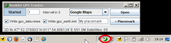
What does it do?
- Store the (raw) NMEA data
into a file. This data can be used by many applications to view tracks
etc... (GPSBabel can convert this format into any other you can
imagine.)
- Update a KML file which can be used by Google earth to view current position + the track.
- Lets you open the current position in Google Maps and Openstreetmap.
- Lets you send geo-located tweets (ok, this is bonus, because I love twitter, BTW: follow me, I'm @andizottmann on twiitter .! )
- Maintains a Placemark file in KML format.
How to install
- Install Java, you'll get that at java.com
- Install the DLL's from rxtx:
- Download this file and unzip it: http://rxtx.qbang.org/pub/rxtx/rxtx-2.1-7-bins-r2.zip
- Follow those installation instructions: http://rxtx.qbang.org/wiki/index.php/Installation_for_Windows
- Download this ZIP-file and unzip it to a folder of your choice (maybe "Programs")
How to run
- Make sure the "3G"-device on your Booklet is activated. For any reasons this is necessary for the GPS-device to be working.
- Doubleclick on the BookletGPS.jar file to start it (or using the command line "java -jar BookletGPS.jar").
- A Tray icon with a satellite antenna will appear in your Tray.
Functions
- With the "Started"-Button you can Start/Pause the GPS device.
- In the "Intervall" Textfield you can enter the number of seconds (only whole number >=1) it will update GPS data.
- the Open-Combobox offers you some Applications to open with current location (e.g. Map shown in browser, or a geolocated tweet).
- With the two checkboxes "Write gps_data.nmea" and "Write gps_earth.kml" ypu can temporarily stop writing those files.
- With
the "+Placemark" Button you can add a placemark to the placemark-file
titles with the title you give in the field left from this button.
- The status line shows the latest valid GPS position + a little bit more info.
Outcoming files
All files are located in your user-home, which is for me: c:\Users\Andi
gps_data.nmea: the raw NMEA data.
gps_earth.kml:
this file contains the current position and track, ready to be used by
google earth as "Network link". Open google earth and include it as
network-link. You can determine by yourself how often this will update.
This file will be reset each time you restart the application, not when
you just pause it.
placemarks.kml:
This file stores all Placemarks you create. Its perfect to be opened in
google earth, but can by used by many other applications too.
If you like the software or have any problems, please contact me using twitter: @andizottmann is my name!